
The weekend at or immediately prior to the start of November is a possible long weekend for some in Victoria, with many having a rostered day off on Monday prior to a holiday on Tuesday for the Melbourne Cup (a horse race). But many need to work on a normal schedule, myself included. I did manage to organise a day of leave on Friday 31 October 2014.
For many months I have been looking at a cluster of summits in the north of East Gippsland – 5 summits that had not yet been activated, all worth 10 points! I had initially thought that I might manage a four day break, but work pressures limited me to three days. As the weekend approached, the weather forecast was watched with interest. As the weekend approached, the forecast deteriorated!
The weekend started on Friday morning, heading east to Bairnsdale, Bruthen and through Buchan towards Gelantipy.
Mount Seldom Seen VK3/VG-029 1344 m 8 points

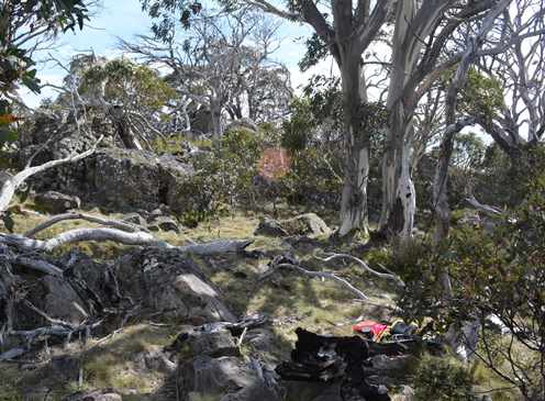
Operating site on Mt Seldom Seen, looking across to the Snowy River National Park
From C608, take Seldom Seen Track and then Lookout Track. You can drive to the summit. The summit has comms gear and a fire tower, and is otherwise bare, so very exposed. I grabbed the pack and walked down the hill to exit the activation zone, back to the summit and set up using a stump to hold the squid pole.
I worked 15 stations, all on 40 m. The wind was very strong, so I was keen to move off the hill quickly.
It was then a case of retracing my route back down to the main road, then north toward Jindabyne, then heading west on Limestone Road. Take note of the warning sign: the road is subject to snow and ice, carrying wheel chains is compulsory in winter. The road was closed for much of the 2014 winter due to heavy snow falls. The road is unsealed and can be rough and slippery when wet. It can be navigated by a 2WD vehicle when dry.
I progressed well and spotted a sign indicating the high point: “The Great Dividing Range” with a HASL (about 1430 m IIRC), plus “Mt Wombargo”. I stopped to check my map and decided that this was a reasonable point to start the climb.
Mount Wombargo VK3/VG-006 1664 m 10 points Not Yet Activated (NYA)

Mt Wombargo Route
Mt Wombargo operating site
There is an area to park to the south of the road just west of the sign mentioned above. An old track starts off this area, but it rapidly becomes unnavigable after a short distance. I headed off along the old track and then followed brumby tracks heading in the right direction or simply across the terrain. I climbed over a large knoll (The Peak on some maps), down into the saddle beyond and then up the spur line to the summit ridge. The day was warming rapidly, partly due to the northerly wind. Once the ridge flattened out somewhat, it was a simple matter to navigate the rocks and fallen timber. The high point appears to be a rocky outcrop. I set up near the base of the rocks, using a tree branch to support the dipole centre at about 3 m above ground.

Mt Wombargo profile
Tony VK3CAT responded to my first call – too easy! This was the first of 15 contacts, all on 40 m. I briefly tried 20 m, with no responses.
The return trip was initially a free form navigation back along the ridge top, then down into the saddle. I then veered to the left to avoid The Peak and its height gain of about 30 m, again following brumby tracks. I soon approached a mob of about 10 brumbies, which then headed off into bush. We encountered each other a few more times over the next half hour. Once back on the main spur below the knoll, my route was again free form, but I safely navigated back to the car without needing to refer to map, compass or GPS.
I headed further west toward Native Dog Flat until I reached Rams Horn Track. The track is a rough in places (not a place for a 2WD), but I managed to get to the high point and find a spot to park off the narrow track.
Rams Head Range VK3/VG-007 1661 m 10 points NYA
From the parking spot, I headed slightly uphill and to the east, to skirt around Rams Horn and into the saddle between Rams Horn and the main summit. It was then a matter of continuing to navigate the fallen timber and rocks until I reached the summit.
As I was setting up on the summit, I noticed that I had again forgotten the GPS, the phone & the camera – left on the passenger seat of the car in my rush to get moving – this is somewhat of a fault! So no GPS track or pictures for this one unfortunately.
First in the log this time was Ken VK3UH followed by 10 more, including S2S with Andrew VK1NAM/p and Nick VK3ANL/p. The activation was short at only 10 minutes, but the time was moving on, so I quit when there were no further responses to my calls.
I retraced my route to the car, headed back to Limestone Road and then west to Native Dog Flat and set up camp.
Mount Cobberas Number 1 VK3/VG-002 1821 m 10 points NYA

Mt Cobberas 1 route
Saturday morning started with an early rise. From Native Dog Flat, I drove east along Limestone Road to Cobberas Track. This track is subject to seasonal road closure, from mid-June to just before the “Cup Day” weekend. The track needs good ground clearance in a vehicle if you are going to attempt to drive. I drove to the start of the Playground Plains to park. I loaded up and headed up the valley. There are 2 signs here: an old “No vehicles beyond this point” and one indicating the start of the Cobberas No 1 walking track. But there is not really an obvious track across the grassy plain. Head upstream and find a suitable spot to cross the creek. I avoided the creek crossing until the spur on the right from Rams Head Range started to narrow the space south of the creek. Shortly after crossing the creek, I spotted the first track indicator. From here on, the track was better defined as it headed roughly west and then climbed steeply out of the valley. All of this is a little frustrating, as you can see the peak to the north, but you are walking parallel to the peak’s ridge and make little apparent progress! The track climbs up to a spur which runs south west off the western end of the main summit ridge. The track then climbs relatively gently, then steeply onto the main ridgeline of the summit, transitioning from subalpine to alpine environment. The final approach is gentle along to the summit on a rocky outcrop amongst the snow gums.

Mt Cobberas 1 profile

Mt Cobberas 1 operating site
By time I reached the top, the wind was quite strong, with a cold front rapidly approaching. The climb had taken around 3 hours to cover the almost 7 km, with a climb of around 500 m vertical. Given the wind, I set up near the base of the summit rocky outcrop, using a snow gum branch to hold the dipole centre. Once I switched on, I worked VK1ATP/p for a S2S. Conditions appeared strange, with signals highly variable. After working a few stations, the rain arrived. I worked a few more stations, and asked if anyone was aware of plans of VK2TWR & VK2QR, as I was aware of their plan to perhaps activate some summits. No one had any news. It was about 10 minutes prior to UTC rollover, with the temperature dropping rapidly and the rain turning to sleet. I decided to pack up and leave, before the weather worsened.
It should have been a simple case of retracing the route back to the car, but with the rain and cloud I somehow missed the cairns where the track heads off the ridge line, resulting in me travelling about 500 m further along the ridge until I noticed my mistake. I back tracked and found the small cairns, then resumed the descent. Up until this stage, the wind was very strong and it was sleeting and/or raining heavily. I am sure that it would have been snowing up near the summit by now.
The rest of the return trip was uneventful and I was back at the car by around 0251Z, giving a total trip time of under 6.5 hours, including the activation.
It was then a matter of navigating back down the Cobberas Track back to Limestone Road. I then had a look at possible approaches to Blue Hill (VK3/VG-010) from the road. The likely approach route looked very steep, with a large rocky face obvious on the north face. Given the weather and the day’s exertions so far, I decided that this one could wait for another day!
So it was back to camp and a short period of listening on 40 m in the brief period without rain. The temperature was dropping and the rain kept coming. I retired top the tent for an hour or 2, having a long nap. The evening meal was prepared and consumed early, with an early night to the comfort of the warm sleeping bag with the rain continuing to fall.
Sunday morning was clear and cold. Some water emptied from an insulated container in the car froze within 10 minutes of being emptied into a cup on the picnic table, so it was very cold! The tent was covered in a thin layer of ice.
After breakfast, I packed up and headed off toward Benambra along Limestone Road, the turned on to Misery Road. At the junction of Misery Road and Misery Track, there was a large Road Advisory sign indicating that both Dapples Creek Track and Macs Creek Track were closed due to failed log bridges – 2 possible approach routes to a possible target summit (VK3/VG-009) were therefore ruled out. The sign indicated that alternate approach routes to Davies Plain were Limestone Creek Track and Misery Trail. Davies Plain has a SOTA summit, but is a difficult 4WD track to navigate to the summit, and much further than I had planned for the day. I headed up Misery Trail, which soon started to get rougher. After passing Windy Point, the track veers right onto a steep section. The section looked very wet after the rain, and was very cut up and rocky. Not something to tackle in a Forester when by oneself! So I abandoned attempts to get to VK3/VG-009 and Mount Misery Range (VK3/VG-008).
I retraced my route to Limestone Road and headed to Benambra. From there I headed toward Omeo and up McKenzies Road and then The Sisters Track. I got part of the way up until a very rough section & decided to park and walk the rest of the approach route.
The new target was The Sisters.
The Sisters VK3/VG-044 1231 m 8 points

The Sisters route
The walking approach was a little less than 2 km from where I parked the car. Having examined the map, I elected to veer off The Sisters Track at the high point near the southern peak, into a shallow saddle and then contour around and slightly up into the saddle between the two peaks. Thickets and fallen timber drove me a little higher than I had wished, but the final approach to the saddle was easier as the southern approach to the saddle has been burnt. It was then a steady climb from the saddle up to the summit dodging rocks and fallen timber. There is a large rock cairn on the summit itself.

The Sisters profile
I set up using a branch to support the dipole centre at about 3 m. There was a convenient “shelf” on the side of the cairn upon which to sit the radio.
First in the log was Bernard VK2IB/3 for a S2S contact at 2333 Z, followed almost immediately by Andrew VK1NAM/2 for another S2S. Bernard and Andrew were worked again after UTC rollover, and contacts started to become scarce after 0020Z. I took some photos and had a snack, waiting for Rod VK2TWR to get to his first summit for the day. I worked Rod S2S at about 0112Z and then waited for Bernard on his second summit to go to SSB at 0134Z – I had heard him on CW earlier, but had no key with me, so needed to wait for him to go to SSB. Bernard was contact 38 from this summit and I then packed up.
The return trip was essentially a rough retrace of the route back to the main saddle. I then veered left a little down a minor spur as it looked relatively open. I crossed a shallow gully and then descended toward The Sisters Track through some burnt and other relatively open terrain. Lower down I spotted an opening in the scrub near the creek line at the bottom, just below the main track. It was then a simple matter to climb back up along the track and to return to the car.
I then drove back toward the Omeo-Benambra Road, then to Omeo for a very late lunch. Whilst waiting for lunch to be bought out, RRT announced Bernard on his last summit on SSB. By time lunch arrived and I got back to the car, Bernard had gone – a chasing opportunity missed. I then headed to the last target for the weekend.
VK3/VG-064 unnamed summit 1038 m 6 points
I was the first to activate this summit back in September 2013. It is not far off the Cassilis Road, which is part of a scenic/tourist route. One can drive to the AZ. I parked near the summit and exited the AZ and walked back up and set up. First in the log was Rod VK2TWR/p on his second summit for the day. A nice start! I made 13 contacts and spent several minutes calling on 20 m without any response before going back to 40 m. I gave up after about 15 minutes, with no further responses to my calls.
About 30 minutes after the last contact, I had a contact from the car with Marshall VK3MRG/p on a summit. If he had posted an alert, I may have waited for him to come up for another S2S opportunity.
It was then a matter of driving home, with a break at Bairnsdale to chat with Rob VK3EK.
Overall, it was a tiring but rewarding weekend. I activated only one summit that I had previously activated, activated 5 summits that were uniques for me, including three first time activations. Amongst the contacts were 10 S2S contacts. Plus I had my first visit into the Cobberas area, with a couple of summits to tackle in the future.
Many thanks to all the chasers who worked me and to those who I worked for S2S.

Pingback: East Gippsland Day 1 - 10 October 2015 - VK3IL BlogVK3IL Blog